

Caerphilly Blackwood High Street
Caerphilly Blackwood High Street closed on 01/04/2025
You can still view any information available using the Site Information tab, or find data in the Data section.
For more information on this monitoring data please contact this local authority.
Caerphilly Blackwood High Street closed on 01/04/2025
You can still view any information available using the Site Information tab, or find data in the Data section.
Statistics for Caerphilly Blackwood High Street
| Site Name | Caerphilly Blackwood High Street |
|---|---|
| Site Type | Roadside |
| Easting, Northing | 317456, 197109 |
| Latitude, Longitude | 51.666667, -3.194919 |
| OS Grid Ref | |
| Address | |
| Site Comments | High St, Blackwood |
| Monitoring Network: Welsh Automatic Urban pollution Monitoring | ||
|---|---|---|
| Parameter | Date Started | Date Ended |
| Nitric Oxide | 14/01/2009 | 01/04/2025 |
| Modelled Temperature | 01/08/2010 | 01/04/2025 |
| Nitrogen dioxide | 14/01/2009 | 01/04/2025 |
| Modelled Wind Speed | 01/08/2010 | 01/04/2025 |
| Nitrogen oxides as nitrogen dioxide | 14/01/2009 | 01/04/2025 |
| Modelled Wind Direction | 01/08/2010 | 01/04/2025 |
| Particulates < 10um (hourly measured) | 14/01/2009 | 01/04/2025 |
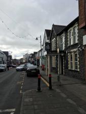
The photographs show the site itself, and views looking North, East, South and West.
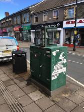
Monitoring Site Photo
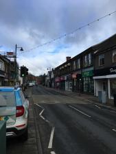
View North

View East
View South

View West
Click the button below to create the PDF statistics report for the chosen year and site above. Please note that it is stated within the report text itself whether data used to create the statistical report is ratified or provisional.
Note: it may take a few seconds to generate the report.